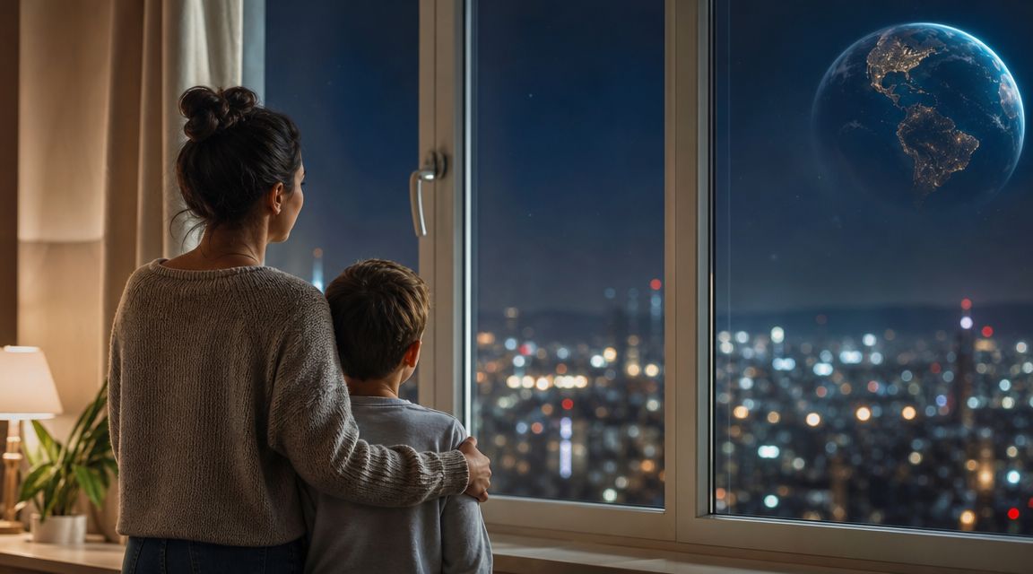
You might be reading this at home while a child points out the streetlights outside, or while a class asks one of those brilliant questions that seems simple at first. What does Earth look like at night from space?
This phenomenon combines part magic, part science, and part detective work. The glowing patterns we see aren't just pretty. They can help us think about cities, roads, weather, fires, and even how people live across the planet.
Have You Ever Seen Earth's Night-Time Sparkle
You are at the window with Space Ranger Fred after supper. A few lights click on across the street. One house glows softly. A car slides by. Farther away, the town centre shines brighter than the quiet road outside. Have you ever wondered what your neighbourhood would look like if you could float high above it in space?
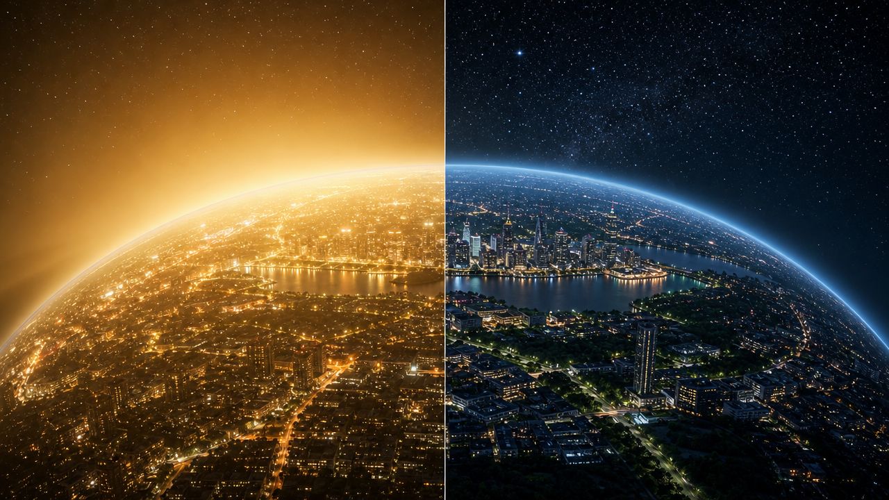
From orbit, Earth at night can look like dark velvet stitched with gold. Big cities gather into bright bunches. Roads stretch out like glowing strings. Some coastlines shine so clearly that they look as if someone traced the edge of the land with a gentle pencil of light.
That picture feels magical because it is both familiar and strange. You know what a lamp post looks like. You know the glow of a kitchen window. From space, those tiny local lights join into enormous patterns. A child can spot the same idea at two scales. One street becomes part of a town. One town becomes part of a country.
Why this picture feels so special
Many children guess that the famous night view is a single photo snapped from a spacecraft window. Plenty of grown-ups guess that too. The actual answer is even more interesting, and Space Ranger Fred would tell you that good space questions often have answers that are bigger than the first guess.
Scientists use these glowing patterns to study how people light the land, where activity gathers, and how different places change over time. Light is part of the wider story of how we see the universe. If your young explorer wants a simple primer, this guide to the electromagnetic spectrum helps explain what light is.
So the night view is beautiful, and it is useful too.
Big idea: The night view of Earth is a map made from light, and light leaves clues.
In Britain, those clues can be easy to notice because many towns and cities sit fairly close together. London glows strongly. Other busy areas connect in bright chains and clusters. If a child has ever looked down from an aeroplane and seen towns linked by roads, this space view feels like the same idea seen from much higher up.
Here is a fun family question to try tonight. Which parts of your own neighbourhood would shine brightest from above? The high street? The football ground? The supermarket car park? A simple hand-drawn night map can help children connect their world to satellite science, a bit like the way a guide to AI-powered image improvement shows how clearer pictures help hidden details stand out.
The Super Special Cameras That See in the Dark
A family camera would have a hard time taking a clear picture of Earth at night from orbit. There is only a tiny amount of light to work with. Some of it comes from cities, some from the Moon, and some from things like boats, fires, and even faint glow in the atmosphere. From hundreds of kilometres up, that is a tricky scene to capture.
Scientists solve that problem with sensors built to notice very dim light.
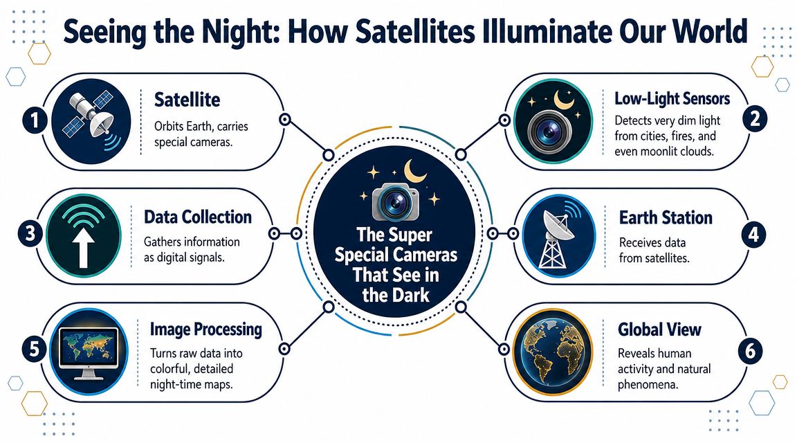
These instruments work a bit like owl eyes paired with a highly sensitive camera. They are designed to pick up light that would slip past ordinary cameras. One of the best-known tools is VIIRS, carried on the Suomi NPP satellite. It gathers faint night-time signals from Earth so scientists can build those famous glowing world views.
Here is the surprising part. The picture you see of Earth at night is usually not one click, one moment, one giant photograph.
Not a photograph but a giant puzzle
Satellites travel in paths around Earth and collect narrow strips of information as they pass overhead. Scientists then sort through those strips, remove cloud-covered parts, and combine the clearest pieces into a larger map. So the final night view is assembled carefully, more like building a giant family jigsaw on the kitchen table than snapping a quick holiday photo.
That can confuse children at first. If the whole planet is round, why not just take one big picture? The answer is simple. Night-time light is faint, clouds get in the way, and satellites only see part of Earth at a time.
A handy way to explain it at home is this:
- One satellite pass gathers one strip of the scene
- Many passes collect enough pieces to cover much more of the planet
- Scientists assemble the pieces into the glowing map people recognise
Space Ranger Fred would probably ask, "What would your street look like if a satellite flew over tonight?" That question turns the science into something children can test for themselves. They can sketch their road, mark the brightest places, then compare that little hand-made map with the way satellites build a bigger one from above.
If your young space fan wants to know how visible light fits into the bigger family of light, this friendly guide to what the electromagnetic spectrum is is a great next stop.
Here's a visual to watch after that idea has settled in:
Why images need careful processing
The raw data does not arrive looking like a polished poster. Scientists have to line it up, clean it, compare passes, and make sure the final view is readable. That careful processing helps turn faint signals into a map families, teachers, and researchers can use.
You can compare it to cleaning a foggy window. The view was there all along, but you need the right method to see it clearly. If you're curious about how image clarity can change the way people understand a picture, this guide to AI-powered image improvement offers a helpful look at the wider idea of enhancing visual detail. It isn't about replacing the science. It helps explain why image processing matters.
Cloud-free night maps are built, checked, and assembled. They are carefully prepared views of a very dim world.
What Are All Those Glowing Patches
You are peeking down at Earth after sunset. The oceans look dark, then suddenly you spot golden webs, bright clusters, and a few odd glows in places where no city should be. So what exactly are you seeing?
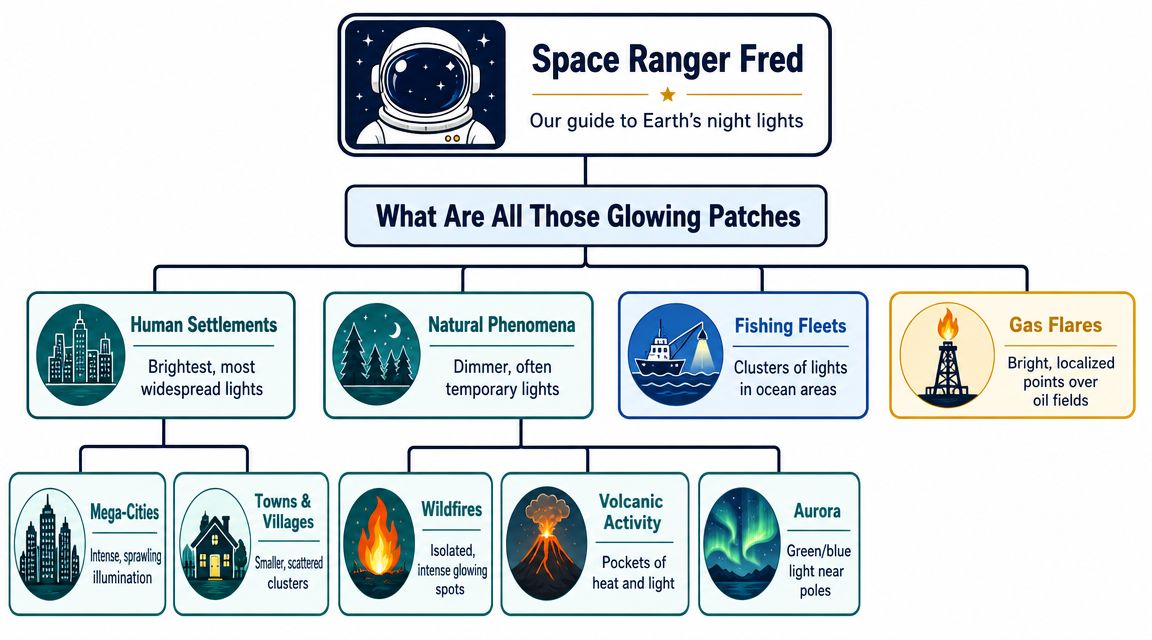
Some patches are exactly what children guess first. Cities. Towns. Busy roads. They shine like your neighbourhood would if every porch light, shop sign, stadium lamp, and streetlight joined the same giant dot-to-dot picture.
Large urban areas often look like glowing islands on land. In the UK, London shines strongly, while other built-up areas can blend into long bright corridors. Roads may appear like threads stitched between places. Coastal towns can even trace the edge of the land more clearly than a cloudy daytime photo.
Then the map gets more interesting.
A glow does not always mean "city." Some lights come from human activity far from home, and some come from nature itself. That is why night images feel a bit like a detective puzzle. Space Ranger Fred would say you are reading clues, not just staring at a pretty picture.
Here are a few surprising ones children love to spot:
- Fishing fleets can sparkle over dark water when boats use strong lamps
- Fires can show up as hot, bright points
- Auroras can spread in swirls and curtains instead of neat city shapes. If your family wants to know more about those glowing skies, this guide to what auroras are and why they shimmer fits perfectly here
- Some clouds or haze can appear faintly because the sensors are built to catch very dim light
A simple way to sort the view is to ask, "Does this shape look built by people, or does it look wild?" A big round cluster often points to a city. A long thin line can be a road or a chain of towns. A strange lonely hotspot might be a fire or industrial site. A soft blur can come from haze, cloud, or light spreading through the air.
| Pattern you notice | It might suggest |
|---|---|
| Big bright cluster | A large city or dense urban area |
| Thin glowing line | Roads or linked settlements |
| Isolated hotspot | Fire or industrial activity |
| Soft broad glow | Cloud, haze, or widespread illumination |
This is a fun moment to try a tiny mission at home. Ask your child to draw a simple night map of your area from memory. Where are the brightest streets? Where is the football pitch, supermarket, station, or harbour? Then compare that handmade map with a satellite view later. The goal is not to be perfect. The goal is to notice how local life leaves patterns that space cameras can spot from far above.
Some night lights show where people live. Others show what people do. A few show what nature is doing too.
That mix is what makes Earth at night so exciting. It is part map, part mystery, and part storybook written in light.
Our Planet's Glowing Report Card
At first glance, it seems obvious that brighter must mean better. More light. More activity. More energy. Job done.
But that isn't always true.
Why brighter isn't always better
Light helps us travel safely, work after sunset, and find our front door without stepping on the cat. Yet too much poorly aimed light can wash out the stars and make the sky look pale instead of deep black.
It can also raise thoughtful questions about energy use and light pollution. If light spills upward or sideways rather than shining where it's needed, then some of that glow isn't helping anyone much at all.
NASA research discussed in this report on Black Marble night-light findings found a 34% increase overall from 2014 to 2022, but many populated places became dimmer. That tells us something important. Night brightness changes in complicated ways.
A better question to ask
Instead of asking, "Is Britain bright at night?" try asking:
- Where is the light concentrated
- How has it changed over time
- Is the light useful, wasteful, or both
- What might local context explain
That last question matters most. A town might look different because of new lighting technology. A transport route might appear brighter or dimmer for reasons that have nothing to do with population. Scientists get the best answers by comparing longer-term patterns rather than trusting one dramatic image.
Practical rule: Treat night-light maps as evidence to investigate, not as instant answers.
Your Mission Become a Night-Light Detective
Space Ranger Fred has a mission for you. After supper, when your street begins to glow and the sky turns dark blue, step outside with a grown-up and look at your neighbourhood like a satellite scientist would.
Suddenly, ordinary places can feel new. The corner shop becomes a bright patch. A row of windows becomes a little cluster of stars. A quiet park may almost disappear. Why do some places shine so strongly while others stay dim? What would a camera high above Earth notice first?
Your local light survey
Bring a notebook, a pencil, and a simple sketch map of your street. You do not need special gear. Your eyes are your first science tool.
Try this small detective checklist:
Spot the sources
Where is the light coming from? Streetlamps, windows, traffic, signs, porches, bus stops?Look at the direction
Does the light shine down onto the ground, or does some of it spill sideways and upward?Notice the colour
Is it yellow, orange, soft white, or blue-white? Does one colour feel harsher than another?Check the shadows
Which places feel easy to see in, and which corners stay dark?Think like a satellite
If you were far above your road, which spots would show up as the brightest glowing patches?
A child can do real observation here. That is the exciting part. You are turning a walk into a mini space investigation.
Questions that help children explain what they see
Ask simple questions and let children answer in their own words.
- Which place looks brightest?
- Which lights seem helpful for people walking or driving?
- Which ones seem too strong or badly aimed?
- Where can you still see a few stars?
- Does your map show one bright centre, or lots of little glowing dots?
After your walk, compare your hand-drawn map with what satellites do from orbit. They collect clues from high above, while you collect clues from ground level. The two views work like a big puzzle and a small puzzle of the same place. If your child wants to know how that orbit view works, this guide to how satellites work makes the connection easier to see.
You can keep the mission going at home, too. Circle the brightest spots on your map. Mark the darkest ones with a different colour. Then ask one last question. If Earth looked down at your neighbourhood tonight, what story would your lights tell?
Now You Can Explain Our Planet's Sparkle
You are standing at the window with a child after your night-light detective walk. Streetlamps glow on your road. A brighter patch marks the town centre. A few darker corners hide between houses and trees. Then comes the big question. If Earth looked back at us from space tonight, what would it see?
Now you can answer it clearly.
Earth at night from space is a science picture built from many careful observations. Satellites use special sensors to spot different kinds of light and glow across our planet. Scientists then combine those observations into maps and visualisations that help us notice where people live, where activity gathers, where fires burn, and where auroras shimmer near the poles.
For children, the clearest explanation is often the best one. Earth's sparkle works a bit like a neighbourhood map made of light. Busy places usually shine more. Quiet places stay dimmer. Natural events can glow too, which is why not every bright patch means a city.
A child could explain it like this:
- The bright areas often show where lots of people are active
- Some glowing shapes come from roads, towns, and cities
- Some lights come from nature, such as fires or auroras
- The famous view is usually made from many observations combined together
- My own street map helps me understand what satellites are seeing from high above
That is real understanding. A child is connecting a giant view of Earth to one small walk around home. Space Ranger Fred would call that a proper mission report.
NASA's visualisation of night-light maps from 2012 to 2023 helps families see one more powerful idea. Night maps are not only beautiful. They also let us compare places across time and ask better questions. Where is a city growing? Where did lighting change? Where do bright areas spread, shrink, or stay steady?
That is the wonder of it.
A glowing Earth is not only a pretty picture on a screen. It is a way to read clues about life on our planet, from orbit to your own neighbourhood. And once a child has drawn a light map, spotted bright patches, and asked why some places shine more than others, they are no longer just looking at Earth at night. They are starting to understand it.
Keep the adventure going with Space Ranger Fred. You can explore fun space books that build reading confidence while sneaking in real STEM learning, and they're perfect for curious children, families, classrooms, and libraries. If you'd like an engaging author visit too, Space Ranger Fred school visits bring interactive storytelling, space science, reading excitement, and confidence-building communication into your school in a way children remember long after the session ends. Learning should be experienced, not just delivered.